Global Warming Policy Foundation
17 June 2014
Doubts Surface Over 2014 El Niño Development As Warming Stalls
A top British expert has come out with new research flatly contradicting the idea that extremely cold winters in North America – like the one just past – will become more frequent due to global warming. This new analysis disagrees completely with the assessment of President Obama’s science advisor. –Lewis Page, The Register, 16 June 2014
1) UK Study Debunks Obama’s Science Advisory Climate Theory – The Register, 16 June 2014
2) Doubts Surface Over 2014 El Niño Development As Warming Stalls – Reporting Climate Science, 17 June 2014
3) El Niño 2014: Early Strength Fades – Inform the Pundits, 12 June 2014
4) David Whitehouse: Is A Super El Niño On The Way? – The Global Warming Policy Foundation, 13 May 2014
5) Flashback 1997: Climate Scientists Forecast Permanent El Niños – Not A Lot Of People Know That, 16 June 2014
A growing body of evidence suggests that the kind of extreme cold experienced by the United States is a pattern we can expect to see with increasing frequency as global warming continues. I believe the odds are that we can expect as a result of global warming to see more of this pattern of extreme cold. –Dr John Holdren, President Obama’s science and technology adviser, 7 January 2014
Climate change is unlikely to lead to more days of extreme cold, similar to those that gripped the USA in a deep freeze last winter … Recent changes in the Arctic climate have actually reduced the risk of cold extremes across large swathes of the Northern Hemisphere.— University of Exeter, 16 June 2014
For the last month or so, both the National Oceanic and Atmospheric Administration (NOAA) of the US and Australia’s Bureau of Meteorology (BoM) have been predicting that an El Nino is likely to develop in the Pacific later this year as a large bubble of warm water rises off Indonesia and moves eastwards towards the western coast of the Americas. However, Pacific Ocean sea surface warming has “levelled off” in recent weeks and changes in key measures run “counter to typical El Nino development” while computer model forecasts of the so called El Nino Southern Oscillation (ENSO) have eased, according to BoM. —Reporting Climate Science, 17 June 2014
Last March saw the highest subsurface ocean temperatures ever measured so early in an El Niño event. Speculation suggested this year’s event might be a repeat of the super El Niño of 1997-98. That one was the exclamation point at the end of the last massive global warming cycle that stopped 15 years ago. New model forecasts out this month suggest that the consensus probability of El Niño this summer and winter is higher than ever, up to 80 percent by midwinter. However, those hoping El Niño 2014 will kick-start another round of global warming may be greatly disappointed. Basically, the PDO this year is sucking the heat out of El Niño 2014. —Inform the Pundits, 12 June 2014
This year could be the hottest ever, due to the high possibility of an El Niño weather phenomenon. Piers Forster, a professor of climate change at Leeds University, told RTCC that an El Niño combined with the effects of global warming, could make 2014 the hottest year on record. “The prediction that 2014 will be the hottest year on record is a rough estimate but based on sound physics and the latest predictions for the growing El Niño during the remainder of the year,” said Forster. –Sophie Yeo, Responding to Climate Change, 17 June 2014
There has been some discussion recently about the possibility of an El Nino starting later this year and if it will restart global warming. Certainly if the usual effect of an El Nino – warming of the surface waters of the equatorial Pacific – happens and the global annual average surface temperature reaches a new record because of it, perhaps only by a few thousandths of a degree, then it will be hailed by some as a “resumption” of global warming… I don’t think that it will be a record breaker because there is less heat stored in the Pacific now than there was in the years preceding the 1997-8 event. –David Whitehouse, The Global Warming Policy Foundation, 13 May 2014
Scientists are warning that global warming could make the El Nino a permanent feature of the world’s weather system. El Nino events normally occur roughly every 5 years, and last for between 12 and 18 months. However unpublished scientific research now suggests that the complex weather systems could occur every 3 years, making them a dominant weather pattern and in effect, almost permanent. –BBC News, 7 November 1997
As for the Incas placating the Gods for a bit of bad weather, are we really so much more advanced these days? We might no longer sacrifice lives, but our efforts to placate the Gods of Decarbonisation will probably be regarded by future generations as just as pointless. – Paul Homewood, Not A Lot Of People Know That, 16 June 2014
1) Wrong Again: UK Study Debunks Obama’s Science Advisory Climate Theory
The Register, 16 June 2014
Lewis Page
A top British expert has come out with new research flatly contradicting the idea that extremely cold winters in North America – like the one just past – will become more frequent due to global warming. This new analysis disagrees completely with the assessment of President Obama’s science advisor.
Dr James Screen of Exeter uni in England is a mathematician who has been studying the arctic ice sheet for several years. According to a university announcement highlighting his latest research:
Climate change is unlikely to lead to more days of extreme cold, similar to those that gripped the USA in a deep freeze last winter … [Recent changes in the Arctic climate have] actually reduced the risk of cold extremes across large swathes of the Northern Hemisphere.
Screen’s new paper is published in the hefty climate journal Nature Climate Change. In it he writes:
Subseasonal cold-season temperature variability has significantly decreased over the mid- to high-latitude Northern Hemisphere in recent decades. This is partly because northerly winds and associated cold days are warming more rapidly than southerly winds and warm days … decreases in subseasonal cold-season temperature variability … are detectable in the observational record and are highly robust in twenty-first-century climate model simulations.
Or, in other words, severe cold spells like the ones Americans and Canadians have just suffered through are not increasing in frequency and shouldn’t be expected to.
That contradicts very sharply with the view of Dr John Holdren, president Obama’s White House science and technology adviser. He says:
“A growing body of evidence suggests that the kind of extreme cold experienced by the United States is a pattern we can expect to see with increasing frequency as global warming continues.”
“I believe the odds are that we can expect as a result of global warming to see more of this pattern of extreme cold.”
2) Doubts Surface Over 2014 El Niño Development As Warming Stalls
Reporting Climate Science, 17 June 2014
Pacific Ocean warming has levelled off in recent weeks, computer model forecasts have eased and key metrics are not in line with typical El Nino development but Australia’s Bureau of Meteorology still expects an El Nino to brew in the Southern Hemisphere Spring and it is maintaining its El Nino alert outlook status, according to its latest report.

A degree of uncertainty now exists over the development of the expected El Nino Pacific Ocean warming event this year following the release of new data.
For the last month or so, both the National Oceanic and Atmospheric Administration (NOAA) of the US and Australia’s Bureau of Meteorology (BoM) have been predicting that an El Nino is likely to develop in the Pacific later this year as a large bubble of warm water rises off Indonesia and moves eastwards towards the western coast of the Americas.
However, Pacific Ocean sea surface warming has “levelled off” in recent weeks and changes in key measures run “counter to typical El Nino development” while computer model forecasts of the so called El Nino Southern Oscillation (ENSO) have eased, according to BoM. However, “The Bureau’s ENSO Tracker remains at El Nino ALERT, indicating at least a 70% chance of El Nino developing in 2014,” states BoM in its most recent report issued today (17 June 2014).
Positive sea surface temperature anomalies (that is, warming) remain evident across much of the Pacific but the area of warmer than average sub surface water that drives El Nino sea surface surface warming has shrunk, according to BoM. It states that “overall there has been a reduction in the area of sub-surface water very much warmer than average over the past month and a half”.
Furthermore, the Southern Oscillation Index (SOI) – a measure of the atmospheric pressure difference between Tahiti and Darwin in Australia and a lead indicator of El Nino conditions – has risen over the past two weeks and has generally remained around +8 to +10. The latest approximate 30-day SOI value to 15 June is +10.3. Sustained positive values of the SOI above +8 may indicate a La Nina Pacific Ocean cooling event rather than a warming event.
Trade winds are also stronger than would be expected in El Nino conditions, says BoM.
While computer model forecasts from both NOAA (see top right) and BoM (see right second from bottom) of future warming have also flattened. “Despite some easing in the predictions of how much the equatorial Pacific will warm by, the majority of the surveyed models indicate that sea surface temperatures in the equatorial Pacific are likely to exceed El Nino thresholds before or during the southern hemisphere spring,” reports BoM.
El Nino events have a global impact on weather and can result in droughts in Australia and India and rainfall in California as well as cooler than usual winters in Europe. They also have an impact on global average surface temperatures. Some climate scientists have suggested that a particularly strong El Nino this year would result in record global surface temperatures in 2014.
3) El Niño 2014: Early Strength Fades
Inform the Pundits, 12 June 2014
New model forecasts out this month suggest that the consensus probability of El Niño this summer and winter is higher than ever, up to 80 percent by midwinter. However, those hoping El Niño 2014 will kick-start another round of global warming may be greatly disappointed. Basically, the PDO this year is sucking the heat out of El Niño 2014.

NOAA’s Climate Prediction Center released its monthly El Niño report for May, on June 5th. The consensus probability there will be El Niño conditions for the Northern Hemisphere summer jumped to 70 percent, getting as high as 80 percent by late fall and winter.
Last March saw the highest subsurface ocean temperatures ever measured so early in an El Niño event. Speculation suggested this year’s event might be a repeat of the super El Niño of 1997-98. That one was the exclamation point at the end of the last massive global warming cycle that stopped 15 years ago.
However, it’s beginning to look like El Niño 2014 won’t be as strong as previously feared.

Forecasting El Niño is a consensus probability calculated from the average of 22 dynamic and statistical El Niño climate models.
It is the same basic principle as used by the IPCC in its climate models used to forecast global temperature rise. The IPCC has over 100 models. The difference, though, is that the IPCC has yet to achieved forecast reliability. The statistical “hiatus” from warming since 1998 has really messed up IPCC forecasting.
Indications that this year’s El Niño will not be as strong as previously thought comes from new data measuring sea temperatures down to a depth of 300 meters. El Niño is defined as a temperature anomaly ≥ +0.5°C in specifically defined zones.

Subsurface sea temperatures down to 300 meters depth, that had set an all-time record high in March, have now fallen way back to half the pace of the 1997-1998 super El Niño.
The trend appears to be toward a weaker, more normal event for 2014-15.
The PDO Effect
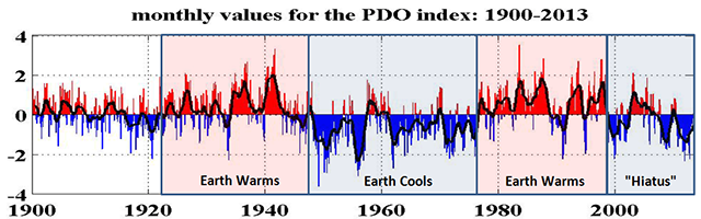
The Pacific Decadal Oscillation (PDO) is a new Pacific ocean phenomena, discovered in 1997, that affects ocean temperatures which, in turn, affects climate change and El Niño. It’s a 20-30 year alternating pattern between warming and cooling. We are about half way through a cooling cycle right now.
Statistically speaking, earth’s temperature stopped rising around 1998 when a down cycle in PDO began. PDO was in an up cycle in the great global warming years of the 1980s and 1990s. It was in a down cycle during the slight global cooling phase of the 1960s and 1970s.
Current speculation among scientists this month, based on the sudden drop in subsurface sea temperatures, is that PDO will mute the impact of El Niño this year. Many now believe it will not be a repeat of the super El Niño of 1997-98 that was at the end of the last up cycle in PDO.
Basically, PDO this year is sucking the heat out of El Niño 2014.
4) David Whitehouse: Is A Super El Niño On The Way?
The Global Warming Policy Foundation, 13 May 2014
Is the El Nino Coming? Possibly, according to these predictions, here, here, here and here.
There has been some discussion recently about the possibility of an El Nino starting later this year and if it will restart global warming. Certainly if the usual effect of an El Nino – warming of the surface waters of the equatorial Pacific – happens and the global annual average surface temperature reaches a new record because of it, perhaps only by a few thousandths of a degree, then it will be hailed by some as a “resumption” of global warming.
Anyone who has turned a globe of the Earth so that they are facing the Pacific Ocean will be in no doubt that it is perhaps the major feature of our planet’s surface. Looking at the globe that way it is hardly possible to see any land at all. When the Sun shines down on the Pacific it has a powerful effect warming the surface waters. Trade winds blow the warmed surface waters to one side of the Pacific where the warm water accumulates in a warm pool storing heat. When those winds reduce in strength the warm pool sloshes back across the Pacific releasing energy, changing current directions and strengths and wind directions that can be felt all over the world. El Ninos happen every few years and are a way of reducing the heat content of the Pacific and distributing it worldwide.
The biggest El Nino on record occurred in 1997-98. It catapulted the world to then record surface temperatures. Unfortunately, its onset was not predicted at the time as well as many thought it would be with most predictions only suggesting a weak event six months ahead of time.
No one knows how an El Nino starts, some say its quasi-periodic nature points to an unstable mode of ocean-atmosphere coupling. Others believe it is related to the behaviour of the thermocline – the interface between warm water at the surface and the cold water below about 100 metres.
When the 1998 El Nino occurred it was a record breaker. In Nasa Giss (current values) it was 0.2 deg C warmer than the years either side of it. In many respects it is one of the dominant features in the global temperature record over the past 40 years. In the 1980s and early 1990s there was little significant increase in global annual average surface temperature. Looking at the surface temperature record it is clear that the 1997-8 El Nino is positioned at a step-change in global surface temperatures from one 15-year period of little warming to another 15-year plus period of the same though at a more elevated temperature. Indeed it was the 1997-8 El Nino’s boost to global surface temperatures that helped the decadal rate of surface temperature increase given by the IPCC, 0.2 deg C, to be “validated.”
Since 1998 El Ninos have not made any statistically significant impact on the global surface temperature. They have raised it slightly causing alarmist claims that global warming has restarted but one year of statistically insignificant increase does not a restart make.
Today, after many post hoc corrections to the temperature data gathered at the time, in Nasa Giss 1998 is the third warmest year behind 2005 and 2010 (other El Nino years) although when one allows for the errors of measurement 1998 is statistically indistinguishable from 2013, 2012, 2011, 2010, 2009, 2007, 2006, 2005, 2003, and 2002. Technically the annual temperature of 2010 was equal to 2005 and only 0.03 deg C above 2007 – 2010 and 2005 were El Nino years, 2007 was a cool La Nina year – though not in statistical terms. The 2010 warmth was not yearlong being confined to two very warm months in March and June. The other ten months were at average or less than average temperature, as defined by the post-1997 surface standstill.
Some, such as Kevin Trenberth, are making a big deal of the putative 2014 El Nino, “there are some things going on in the tropical Pacific Ocean that we haven’t seen since the 1997, 1998 El Nino event…the question is how large it is going to be?”
We’ve been here before with the same commentators. It always happens when an El Nino is imminent see here, here and here.
While an El Nino might nudge temperatures up slightly, which considering the 2014 global surface temperatures seen in the first third of the year is probably the most that can happen this year, I don’t think that it will be a record breaker because there is less heat stored in the Pacific now than there was in the years preceding the 1997-8 event.
Looking at the surface temperature record the way the 1997-8 El Nino changed things is obvious. What will the next super El Nino do, if one is possible in the elevated temperatures of the past 16 years. Will it cause another step up?
Feedback: [email protected]
5) Flashback 1997: Climate Scientists Forecast Permanent El Ninos
Not A Lot Of People Know That, 16 June 2014
Paul Homewood
Back in 1997, the BBC reported:
Scientists are warning that global warming could make the El Nino a permanent feature of the world’s weather system. ‘They’re going to become more intense and in a few years, or a decade or so, we’ll go into a permanent El Nino.’

El Nino events normally occur roughly every 5 years, and last for between 12 and 18 months. However unpublished scientific research now suggests that the complex weather systems could occur every 3 years, making them a dominant weather pattern and in effect, almost permanent.
This year’s El Nino has been one of the strongest on record and has led to:
Droughts in Australia and Papua New Guinea.
Delayed monsoon in South East Asia leaving forest fires to rage out of control, blanketing the region with choking smog.
Storms on the Pacific coast of South and Central America from Chile to Mexico.
Drought in Southern Africa.
Threat of floods in Peru and California
In the last decade there have been 5 El Nino’s, and some scientists believe that rising greenhouse gases and global warming.
That’s a theory endorsed by Dr Russ Schnell, a scientist doing atmospheric research at Mauna Loa Observatory, 11,000 feet up on Hawaii. “It appears that we have a very good case for suggesting that the El Ninos are going to become more frequent, and they’re going to become more intense and in a few years, or a decade or so, we’ll go into a permanent El Nino.”
“So instead of having cool water periods for a year or two, we’ll have El Nino upon El Nino, and that will become the norm. And you’ll have an El Nino, that instead of lasting 18 months, lasts 18 years,” he said.
Incas sacrificed 80 people to stop El Nino
El Nino events have been occurring for thousands of years. It is a natural phenomenon that has always had a profound effect on those who live within its influence.
High in the Peruvian Andes, archeologists have discovered the skeletons of what they believe are human sacrifices, linked to El Nino events, at Inca temples of the Sun and the Moon.
Dr Steve Bourget from the University of East Anglia believes the 80 victims were sacrificed to placate the Gods during El Nino rainstorms. “On the north coast of Peru it almost never rains … it rains like this only during the time of Nino’s.”
He continued, “So that’s why, during an El Nino event the temple was itself just melting down and they probably did the sacrifice in order to try and stop the rains.”
Of course, the Inca priest’s ceremonies were in vain, and if the scientists predictions are accurate, so might the best efforts of 21st century technology.
Meanwhile, back in the real world:


