GWPF | 6 Jan 2016
Australian Bureau of Meteorology Predicts Significant Ocean Cooling
Due to El Niño and global warming, 2015 natural disasters are much less costly than expected, according to a study by an insurance industry group. The insurance industry’s largest losses in recent years are due to severe winter weather. Global warming and El Niño — a weather event that warms up ocean temperatures in South America, causing the United states to get unusually warm for a year — abated these insurance costs, according to Munich Reinsurance America, Inc. Historically, hurricanes are the insurance industry’s biggest weather related expense, but no hurricane made landfall in the United States during 2015. In fact, no major hurricane has made landfall in the U.S. in the last 10 years, setting a new record. –Andrew Follett, Daily Caller News Foundation, 5 January 2015

1) El Niño And Global Warming Make Natural Disasters Less Expensive, Munich Re – Daily Caller News Foundation, 5 January 2015
2) David Whitehouse: El Nino In Decline – Global Warming Policy Forum, 6 January 2015
3) Australian Bureau of Meteorology Predicts Significant Ocean Cooling – Reuters, 6 January 2016
4) Drought Stricken California Welcomes El Nino’s Storms – Associated Press, 6 January 2015
5) 2015 Third Warmest Year In The Satellite Record – Roy W Spencer, 5 January 2015
Sea surface temperature across the equatorial Pacific basin have cooled roughly one-half a degree over the last four weeks. At the same time, a large pool of cold water beneath the surface in the western Pacific has been expanding eastward, nearly doubling in size over the past two months. The consensus of some 25 models is for a decline in sea surface temperature in the Pacific. The El Nino is expected to remain strong through the Northern Hemisphere in the winter with a transition to neutral conditions expected during late spring or early summer 2016. Exactly how long the El Nino conditions persist will determine how warm 2016 will be. If neutral conditions are reached in the Spring and La Nina by the final quarter then 2016 will be somewhat cooler than 2015 though perhaps a little warmer than 2014. With the advent of La Nina, though, 2017 could be much cooler than many recent years. –David Whitehouse, Global Warming Policy Forum, 6 January 2015
The Version 6.0 global average lower tropospheric temperature (LT) anomaly for December, 2015 is +0.44 deg. C, up from the November, 2015 value of +0.33 deg. C. This makes 2015 the third warmest year globally (+0.27 deg C) in the satellite record (since 1979), behind 1998 (+0.48 deg C) and 2010 (+0.34 deg. C). —Roy W Spencer, 5 January 2015
Despite the potential for flooding and mudslides, storms moving toward California were welcome news for a state suffering from a severe drought. But officials warned against reverting to old water-use habits. As the first of the storms drenched the state on Tuesday, authorities cautioned that even the wettest of winters can’t replenish depleted reservoirs and aquifers unless everyone keeps pitching in. California’s water deficit is so deep after four years of drought that a “steady parade of storms” like these will be needed for years to come, said Mike Anderson, climatologist for the state’s Department of Water Resources. “We’re at least on a good trajectory,” he said. “We’ve got to keep it going.” –Kristin J Bender and Scott Smith, Associated Press, 6 January 2015
The 2015-16 El Nino weather event, one of the three strongest in the past 50 years, has peaked in recent weeks and will likely return to “ENSO Neutral” by the second quarter of this year, Australia’s Bureau of Meteorology (BOM) said on Tuesday. “A number of El Nino–Southern Oscillation (ENSO) indicators suggest that the 2015–16 El Nino has peaked in recent weeks,” the BOM said in a statement. “Climate models suggest the 2015–16 El Nino will decline during the coming months, with a return to ENSO neutral likely during the second quarter of 2016.” –Matt Siegel, Reuters, 6 January 2016
1) El Niño And Global Warming Make Natural Disasters Less Expensive, Munich Re
Daily Caller News Foundation, 5 January 2015
Andrew Follett
Due to El Niño and global warming, 2015 natural disasters are much less costly than expected, according to a study by an insurance industry group.
The insurance industry’s largest losses in recent years are due to severe winter weather. Global warming and El Niño — a weather event that warms up ocean temperatures in South America, causing the United states to get unusually warm for a year — abated these insurance costs, according to Munich Reinsurance America, Inc.
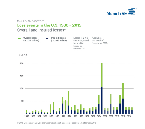
The particularly harsh winter of 2014-2015 caused direct losses of $4.6 billion dollars, 73 percent of which was insured. Losses due to winter weather were also bad during the 2013-2014 winter, the study reported.
Additional insurance industry expenses accrued due to tornadoes, but fewer than 1,200 tornadoes were recorded in the U.S. in 2015 — below the annual average of 1,360. The warming trend also “impacted conditions that led to a quieter overall thunderstorm season,” further reducing losses.
Historically, hurricanes are the insurance industry’s biggest weather related expense, but no hurricane made landfall in the United States during 2015. In fact, no major hurricane has made landfall in the U.S. in the last 10 years, setting a new record. Scientists, however, expect global warming will lead to fewer, but slightly stronger, hurricanes.
Deaths from natural disasters and weather also dropped significantly, according to the study and other sources. Natural disasters claimed 280 lives in the U.S. in 2015 and 270 lives in 2014. Those numbers are dramatically below the 30-year annual average of 580 natural disaster and weather-related deaths.
Extreme weather events like tornadoes and floods have been remarkably less deadly as well in recent years. Thousands of American lives have been saved from tornado and flood deaths due to the weather patterns, according to the charts below.
2) David Whitehouse: El Nino In Decline
Global Warming Policy Forum, 6 January 2015
El Nino’s effect on global temperatures and weather systems has been dramatic in the past few months, achieving records for individual months and, with a significant contribution from the Pacific “Blob,” is bound to make 2015 globally the warmest year of the instrumental era.
Many were expecting the current El Nino to start in 2014. Certainly the signs were there. 2014 started out a lot like 1997 the last great El Nino event. There were some strong westerly wind bursts, big Kelvin waves traversing the Pacific as well as warming in Eastern Pacific. But it didn’t happen, no one knows why, perhaps the westerly wind bursts were too weak and they certainly ended abruptly, perhaps the extreme cold phase of the Pacific Decadal Oscillation, or the extreme cold in South East Tropical Pacific inhibited it. In the event, not all the necessary conditions were maintained for the long-awaited El Nino to commence in 2014.
As can be seen in Fig 1 (click on image to enlarge) the start of the current El Nino took place in May-June 2015.

Since then the warm water has been travelling westward across the Pacific. However, Fig 2 shows the Upper Ocean Heat Anomaly was increasing since February and then declining since December.

This decline is seen in the latest data from the El Nino 3.4 region, Fig 3 (the Nino 3.4 SST anomaly index is an indicator of central tropical Pacific El Nino conditions. It is calculated with SSTs in the box 170°W – 120°W, 5°S – 5°N) which shows the El Nino temperature threshold was reached around May and increased until mid-December.

Such a peak can be seen in other comparison regions, Fig 4. It marks the start of the end of the current El Nino.

Sea surface temperature across the equatorial Pacific basin have cooled roughly one-half a degree over the last four weeks. At the same time, a large pool of cold water beneath the surface in the western Pacific has been expanding eastward, nearly doubling in size over the past two months.
In general terms El Ninos and La Ninas are predictable. The first such prediction was made in 1986 by Mark Cane of the Lamont-Doherty Earth Observatory. Currently about 20 groups make such predictions using models that have demonstrated skill for predictions of up to 6-9 months.
The consensus of some 25 models is for a decline in sea surface temperature in the Pacific. The El Nino is expected to remain strong through the Northern Hemisphere in the winter with a transition to neutral conditions expected during late spring or early summer 2016.
Another indication that the current La Nina is waning comes from observations of trade winds. During the previous “super” El Ninos in 1982 and 1997, western trade winds were highly reversed but abruptly returned to normal within one month at the end of both of those years. Although these winds have not been as anomalously strong in 2015, the same rapid jump occurred last month.
The consensus among international climate models is that by August, sea surface temperature anomalies will be near zero, and are likely to keep declining heading towards La Nina conditions.
Exactly how long the El Nino conditions persist will determine how warm 2016 will be. If neutral conditions are reached in the Spring and La Nina by the final quarter then 2016 will be somewhat cooler than 2015 though perhaps a little warmer than 2014. With the advent of La Nina, though, 2017 could be much cooler than many recent years.
Feedback: [email protected]
3) Australian Bureau of Meteorology Predicts Significant Ocean Cooling
Reuters, 6 January 2016
Matt Siegel
The 2015-16 El Nino weather event, one of the three strongest in the past 50 years, has peaked in recent weeks and will likely return to “ENSO Neutral” by the second quarter of this year, Australia’s Bureau of Meteorology (BOM) said on Tuesday.

The El Nino phenomenon is driven by warm surface water in the eastern Pacific Ocean and is associated with extreme droughts, storms and floods. “ENSO Neutral” periods are marked by ocean temperatures, tropical rainfall patterns and atmospheric winds near the long-term average.
“A number of El Nino–Southern Oscillation (ENSO) indicators suggest that the 2015–16 El Nino has peaked in recent weeks,” the BOM said in a statement.
“Climate models suggest the 2015–16 El Nino will decline during the coming months, with a return to ENSO neutral likely during the second quarter of 2016.”
The agency said that based on data since 1900, some 50 percent of El Ninos have been followed by a neutral year, while 40 percent have been followed by a La Nina, marked by extensive cooling of the central and eastern tropical Pacific Ocean.
4) Drought Stricken California Welcomes El Nino’s Storms
Associated Press, 6 January 2015
Kristin J Bender and Scott Smith
Despite the potential for flooding and mudslides, storms moving toward California were welcome news for a state suffering from a severe drought. But officials warned against reverting to old water-use habits.
As the first of the storms drenched the state on Tuesday, authorities cautioned that even the wettest of winters can’t replenish depleted reservoirs and aquifers unless everyone keeps pitching in.
California’s water deficit is so deep after four years of drought that a “steady parade of storms” like these will be needed for years to come, said Mike Anderson, climatologist for the state’s Department of Water Resources.
“We’re at least on a good trajectory,” he said. “We’ve got to keep it going.”
The current El Nino — a natural warming of the central Pacific Ocean that interacts with the atmosphere and changes weather worldwide — has tied 1997-1998 as the strongest on record, the National Oceanic and Atmospheric Administration’s Climate Prediction Center said, citing statistics that go back to 1950.
El Ninos usually bring heavy rains to California, although it remains to be seen whether people should expect anything like a repeat of 1997 and 1998, when storms killed 17 people, wiped out crops, washed out highways and pushed houses down hillsides.
“DarthNino may finally have California in its sights,” said Jeff Masters, meteorology director of the private Weather Underground.
“A parade of strong Pacific storms characteristic of a strong El Nino event will batter the state this week and will likely bring damaging flooding by the time the second storm in the series rolls through on Wednesday,” Masters said.
However, Masters and meteorologist Ryan Maue of the private WeatherBell Analytics don’t believe this first storm is as powerful as some other Pacific storm systems, and they caution that the storms now following it may land elsewhere.
The current forecast calls for a “kind of a nice level of bombardment” over the next two weeks — probably not enough to cause the tremendous flooding of 1998, but then again, that year’s floods didn’t peak until February, Masters said.
5) 2015 Third Warmest Year In The Satellite Record
Roy W Spencer, 5 January 2015
The Version 6.0 global average lower tropospheric temperature (LT) anomaly for December, 2015 is +0.44 deg. C, up from the November, 2015 value of +0.33 deg. C (click for full size version):
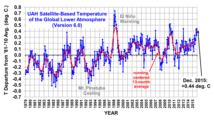
This makes 2015 the third warmest year globally (+0.27 deg C) in the satellite record (since 1979), behind 1998 (+0.48 deg C) and 2010 (+0.34 deg. C). Since 2016 should [?] be warmer than 2015 with the current El Nino, there is a good chance 2016 will end up as a record warm year…it all depends upon how quickly El Nino wanes later in the year.


